Texas Railroad History - Tower 53 (Ney Yard), Tower
124 (Bird's Siding) and Tower 126 (Polk's Tower) - Fort Worth
Three Related Interlockers in South Fort Worth

Above: Rail executive
John W. Barriger III took this photo of Tower 53 sometime in the 1930s or
perhaps the early 40s from the rear platform of his business car as he headed
south out of Fort Worth on the Missouri, Kansas & Texas (MK&T, "Katy") Railway main line. The view is to the north
where Southern Pacific (SP) tracks from Garrett crossed the Katy on the
south side of the
tower. The tower was a Katy concrete design similar to other Katy towers
in Texas built after it (e.g. Tower 64,
Tower 93, Tower 109.)
The small sign hanging from the roofline above the upper floor landing is not
legible. It
is most likely the tower number but it does not appear to be black numerals on a white placard, the
most common design for identification of interlocking towers in Texas. (photo courtesy John W. Barriger III National Railroad Library)
In December, 1879,
railroad magnate Jay Gould was elected President of the Missouri, Kansas &
Texas ("Katy") Railway. This was the culmination of a lengthy effort by
Gould to infiltrate his henchmen into Katy management so that he could
eventually take over the railroad. Normally, Gould would simply buy a
controlling stock interest in a railroad through both public (on the market) and
private sales. Katy stock was so diluted and lacked adequate market
circulation that this was not a feasible approach for Gould, nor were there any large
stockholdings available for private sale. Gould wanted to expand his empire into
Texas and he determined that controlling the Katy railroad was a good place to
start. The Katy's base was in Missouri and the Plains States, but it had built
south through Oklahoma and bridged the Red River in 1873 near
Denison. Gould's plan was to control access from
Texas to the Midwest through the two primary gateways: Denison and
Texarkana. Gould had recently acquired control over
the Missouri Pacific (MP) Railroad based in St. Louis, a major Midwest
carrier. Gould's long-term objective was to capture the
International & Great Northern (I&GN) Railroad, Texas' largest,
which was doing excellent business between Houston
/ Galveston and St. Louis via Texarkana.
By June,
1881, Gould's dominance of the Denison and Texarkana gateways and his recent
election as President of the Texas & Pacific (T&P) Railway spelled doom
for the I&GN. It was dependent on a friendly connection with the T&P at Longview
because it did not have tracks to Texarkana. The I&GN capitulated and agreed
to a takeover by Gould in a swap for Katy stock. In December, 1881, Gould finished the I&GN's route between San Antonio and Laredo,
thereby completing its main line that ran south from Longview through Palestine,
Austin and San Antonio. A year earlier, Gould had leased the Katy
to MP, giving MP its first formal presence in Texas. This was about the time the
T&P had completed its line between Sherman and
Fort Worth which was shared with the Katy south of
Whitesboro. For the Katy, this provided a direct line between Fort Worth and the
Red River bridge. Gould's plan was for the MP / Katy venture to build south from Fort Worth through
Waco and Temple to
Taylor where it would connect with the I&GN main line
to Laredo.
Anticipating this construction, MP / Katy built a yard in south Fort Worth that (at least by 1917) was called
Ney Yard.
Construction proceeded south from Fort Worth, bridged the Brazos River in Waco
in December, 1881, and continued south to Taylor where the I&GN connection was
made in May, 1882.
 |
Left: This image is derived from a larger aerial
photo taken near downtown Fort Worth in 1952.
Tower 126, commonly known as Polk's Tower, is visible immediately east
and slightly north of a crossing of the Gulf, Colorado & Santa Fe (GC&SF)
Railway and the Texas & New Orleans (T&NO) Railway. In 1927, T&NO
became
SP's principal subsidiary for Texas and Louisiana lines. The train is heading
south on Santa Fe tracks and is about to cross the bridge
over Rosedale St., just as its last car is clearing the diamond at
Polk's Tower. The Katy main line is visible at far left with its
bridge over Rosedale. The T&NO bridge is visible between the Katy
and Santa Fe bridges.
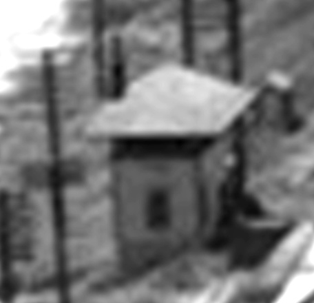
Below: Magnification of the tower does not
convey enough detail to provide conclusive evidence of which
railroad built it. (W. D. Smith c.1952, courtesy UT Arlington Libraries,
hat tip Doug Sutherland and Jim Gibson)
 |
By the time the Katy
had begun building south into the heart of Texas, the Gulf,
Colorado & Santa Fe (GC&SF) Railway was already four years into building north
from Galveston. By April, 1880, it had made only limited progress to
Brenham, but
a flurry of construction continuing through the following year resulted in tracks from Brenham to
Temple and from Temple to Fort Worth by the end of
1881. Santa Fe's
tracks into Fort Worth were west of the Katy's, but both railroads passed
parallel through a major junction with the T&P's east /
west main line near downtown. In 1886, the GC&SF agreed to be acquired by the
much larger Atchison, Topeka & Santa Fe (AT&SF) Railway,
but continued to operate as a wholly-owned subsidiary.
In 1885, Fort Worth
investors chartered the Fort Worth & New Orleans (FW&NO) Railway, ostensibly to
build to New Orleans but in reality, they only needed to build southeast to Waxahachie.
From there, existing tracks of the Waxahachie Tap Railroad provided a connection
to the main line of the Houston & Texas Central (H&TC) Railway at Garrett,
north of Ennis. The H&TC was another SP subsidiary, and its main line ran from
Houston to Denison, hence the primary objective of
the FW&NO was to establish direct Fort Worth - Houston service.
The FW&NO began construction in September, 1885 at Broadway Street where it
established a yard west of both the Katy and Santa Fe tracks, about 500 yds.
south of the T&P junction. At the south end of its yard, the FW&NO built
across the Santa Fe main line to proceed southeast toward Waxahachie. For the Polk Brothers, this junction of two
railroads seemed to be the ideal spot for their new stockyard.
At a 2017 presentation for the
Society of Historical Archeology in Fort
Worth, Harding Polk II summarized the history of Polk's Stockyard, which was
founded by his grandfather, James Hilliard Polk, a cousin of U. S. President James K.
Polk.
Brothers James Hilliard Polk and
Lucius Junius Polk banded together to form the Polk Brothers Livestock
stockyards of Fort Worth. Established in 1885 they were the first stockyard in
Fort Worth. They were located south of the present Fort Worth Union stockyards
and situated conveniently at the intersection of two rail lines. One notable
contract they received was to supply the British Army with horses and mules
during the Boer Wars in South Africa at the turn of the twentieth century.
Around 1914 the stockyards burned, ending the enterprise.
Crossing the Santa Fe tracks was not enough for the
FW&NO; it still needed to go around Ney Yard to proceed southeast out of
Fort Worth. To do so, the FW&NO built
south for a mile before curving southeast to
cross the Katy beyond the south end of Ney Yard. This crossing was probably
built in the fall of 1885 because, according to Fort
Worth lore, locals had already nicknamed it Buttermilk Junction by the time a famous gun
battle had occurred there in April, 1886. The following year, the FW&NO was
acquired by SP and assigned to the H&TC. In 1901, the Legislature authorized
H&TC to merge both the FW&NO and the Waxahachie Tap into a single H&TC
branch. The H&TC continued operating as a wholly-owned subsidiary of SP until it
was leased by (1927), and then merged into (1934), the T&NO.
Shortly
after the FW&NO started construction to Waxahachie, the newly
chartered Fort Worth & Rio Grande (FW&RG) Railway began building
southwest out of
Fort Worth. Financing was largely provided by the
Vanderbilt syndicate which had dreams of extending the railroad to the Pacific Ocean
harbor at Topolobampo, Mexico (an idea later attempted
by Arthur Stilwell.) Construction began in 1886 west of downtown near the T&P tracks at
Hemphill St. and (what is now) Vickery Blvd. The FW&RG line finally reached
Brownwood in 1891, and that same year, the FW&RG built a spur in Fort Worth for interchange with
the Katy and the H&TC. It departed the main line at a location later called
Belt
Junction and ran due east to the Katy tracks before turning north to the
Katy / H&TC crossing. About midway between Belt Junction and the Katy tracks, the
spur crossed the Santa Fe main line to Temple at a location known as Bird's Siding.
By 1888,
Santa Fe had expanded west from Temple through Brownwood to
San Angelo to pursue livestock shipping from a vast, sparsely populated
area of cattle and sheep ranches. This put Santa Fe in direct competition with the
FW&RG which was in the midst of building from Fort
Worth to Brownwood (where the two railroads eventually crossed, though the site
was never
interlocked.) The two companies competed but they also cooperated in
livestock shipments. It was not uncommon for Santa Fe livestock cars to be
handed over to the FW&RG in Brownwood for transport to Bird's Siding where they
would be handed back to Santa Fe. The FW&RG route was 117 miles shorter from Brownwood to Fort Worth
than Santa Fe's route through Temple. Time and distance were important for livestock shipments because the
law required railroads to perform feeding and watering at specific intervals. Ultimately,
it made sense for Santa Fe to own the Fort Worth - Brownwood line, so they
purchased the FW&RG in 1937. The seller was the St. Louis and San Francisco
("Frisco") Railway which had acquired the FW&RG in 1901. The sale
to Santa Fe did not include tracks north of Belt Junction as
these led to Frisco's yard which supported its operations on lines into Fort
Worth from the north. Santa Fe needed
the spur tracks between Bird's Siding and Belt Junction to connect the Brownwood line
to its Fort Worth track network, but the Frisco needed the entire spur so it
could continue to interchange with the Katy and the H&TC. Which railroad
owned the spur and which had rights on it has not been determined.
 |
Left: This excerpt from court records of a 1902
damages lawsuit against the FW&RG and Santa Fe shows how a
cattle shipment from San Angelo to Corsicana involved interchanges at
both
Brownwood and Bird's Siding.
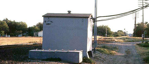
Right: Facing south toward the Santa Fe crossing at W. Biddison St., this 2002 photo shows an older style equipment cabin
often used for interlocking plants.
The
writing on the side of the cabin says "West End, Bird's". (Jim King photo) |
 |
In 1903, the
I&GN finished a main line from Waco
to Fort Worth that passed over the H&TC on a bridge a mile southeast of the Katy / H&TC
crossing. From just south of the bridge, the I&GN built an interchange track
that paralleled the H&TC tracks all the way to the crossing. Like the
FW&RG, the I&GN made connections and perhaps maintained sidings at the junction,
but they did not cross any other railroad; only the H&TC and Katy actually
crossed. This was significant because in July, 1901, a new state law mandated
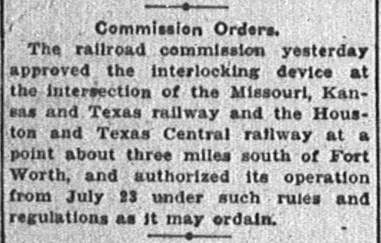
interlockers for busy railroad crossings. On July 23, 1904, the Railroad
Commission of Texas (RCT) authorized Tower 53 to begin operations at this
crossing which it officially listed as being located "South of Ft.
Worth".
Right:
Austin Statesman, July 28,
1904 |
 |
The Tower 53 interlocking
plant was built by Union Switch & Signal Co. and was configured for twelve
active functions. Twelve was the normal function count for an interlocker with
no sidings or exchange tracks, usually consisting of a home signal,
distant signal and mechanical derail
in each of the four directions. In 1923, RCT's published list of
interlockers added the FW&RG and I&GN as official participants at Tower 53 (and
the function count rose to 25), but the associated track and signal changes have not
been determined. In RCT's list dated December 31, 1926, Tower 53's location was
revised to "Ft. Worth, Ney Yards" but all other information remained unchanged.
One year later, the location changed again, to "South Ft. Worth
(Ney)", and this was RCT's final revision. In 1931, RCT stopped publishing
an annual list of active interlockers.
North of Tower 53, the Katy and
Santa Fe crossings of the T&P near downtown was also interlocked as
Tower 55 in 1904. It then took more than twenty
years for the crossings at Polk's Stockyard and Bird's Siding to become
interlocked. The first of the two became Tower 126 at Polk's on June 15, 1926.
Commonly known to railroaders as Polk's Tower, it was a two-story manned tower
that housed an electric interlocker with 33 functions. RCT's annual list of
active interlockers published December 31, 1926 cites Tower 126 as being located
at "Fort Worth, Polk's Stock Yard". The following year, the report started
calling the location "Ft. Worth (Violet St.)", a street that no longer exists.
(Perhaps the change resulted from RCT realizing that Polk's Stockyard had been
out of business for thirteen years due to the fire in 1914!) Documents in the
RCT interlocker archives at DeGolyer Library, Southern Methodist University
indicate that Polk's Tower was approximately 14 ft. by 20 ft. in size. The image
of Polk's Tower further above is the only one found thus far.
For the FW&RG / Santa Fe crossing, RCT commissioned a
cabin interlocker, Tower 124, at "Fort Worth, Bird's Siding" on November 2,
1926. Cabin interlockers were unmanned huts operated by train crews, typically
used where a busy line (the Santa Fe) crossed a less active line (the FW&RG
spur.) The interlocker was normally set to allow unrestricted movements on the
busier track. When a train on the less active line needed to cross, it would
stop short of the diamond and a crewmember would enter the cabin and the set the
controls to allow his train to pass. During that brief period, trains on the
busier line would see a STOP signal when approaching the
crossing. Once the crewmember's train had crossed, he would reset the signals to
allow unrestricted movements on the busier track. RCT's published list of
current interlockers dated December 31, 1926 shows Tower 124 having six active
functions. This was half the normal minimum because signals and derails were
only needed on the busier line. Train crews on the lightly used line always
stopped, hence fixed signs along that right-of-way were sufficient. RCT's
interlocker list dated December 21, 1928 changed Tower 124's function count to
seven, but the details of that change have not been determined. When the Frisco merged with
Burlington
Northern (BN) in 1980, Frisco's operations shifted to BN's primary Fort Worth &
Denver yard on the north side of town. The former FW&RG spur east of Bird's
Siding was no longer needed and was removed in 1983, but the western part
between Bird's Siding and Belt Junction remained intact for Santa Fe access to
the Brownwood line. In 1994, Santa Fe sold the Brownwood line and it eventually
became owned by the Fort Worth & Western Railroad (FW&WR).

Right: This index for the 1927 Sanborn Fire
Insurance Co. Fort Worth map set has been
annotated to show the tracks of the railroads near Tower 53, Tower 124
(Bird's Siding) and Belt Junction; Polk's Tower is off the top of the
map. Katy Lake and I&GN Lake have also
been highlighted in green, examples of the common practice of steam era
railroads building their own reservoirs. Katy Lake was built in 1907-08 and
survived until 1959 when it was drained as part of the construction of a
large shopping center. I&GN Lake was probably built in 1903 when the I&GN
began serving Fort Worth. It survives today as Echo Lake. |
 |
Jay Gould had been fired by Katy stockholders in 1888
after which he fought a legal battle to retain control of the I&GN. He was
ultimately successful when the Texas Legislature created a new charter for the
Katy in late 1891 that did not permit it to retain ownership of the I&GN. Gould
died a year later and was succeeded by his son George. The Gould family
interests in various railroad properties waned during a series of bankruptcies,
and by 1917, the Gould's were no longer involved with the T&P, MP or I&GN. MP acquired the I&GN
(1925) and in 1930 gained controlling interest in the T&P (it did not exercise
operational control, but the MP and T&P collaborated in many areas.) By 1952, the I&GN
interchange track to Tower 53 had been removed; the right-of-way was repurposed as Cole St. along the south side of Echo
Lake in the 1970s. In 1967-68, MP abandoned the I&GN route
between Waco and Fort Worth, but the former I&GN tracks in Fort Worth are
still intact
north of Everman, a
community in southeast Fort Worth.
On March 20, 1961, RCT
wrote a letter to Santa Fe, T&NO and the Frisco confirming that "Polk's Interlocking" had been officially retired.
(The
Frisco involvement may have been related to trackage rights; it did not have
tracks at Polk's Tower.) T&NO and Santa Fe knew firsthand that they had
removed the
interlocker as this was the culmination of their plan to solve a switching problem. Kal Silverberg explains why the
crossing was removed:
"...a track swap was arranged between SP [T&NO] and Santa Fe, most likely due to SP
not being able to switch at their yard because Santa Fe trains were blocking the
lead. The diamond at Polk's was removed and the roads swapped tracks. A new
diamond was placed underneath the Allen Avenue bridge and the tracks swapped
back. This gave SP more room to switch at the south end of Broadway Yard and led
to the confusing state where Santa Fe used the SP bridge over Rosedale, and SP
used the Santa Fe bridge. There was a hand throw connection to the Katy from the SP just south of the diamond under Allen Avenue. The new
diamond was protected by automatic signals, but appears to have never
been under control of any tower. Since this diamond and Tower 53 were
not interconnected, it was possible for the SP to have a green signal at
Tower 53 (once it was automated), a red signal at the new diamond, and,
if the train was long enough, still block the Katy main line until they
could pull into Broadway Street Yard."
This track topology remained in place into the latter
1990s by which time railroad consolidations had rendered it obsolete.
In 1976, MP merged the T&P and then in 1982, MP was acquired by Union Pacific (UP)
though it operated as a
wholly-owned subsidiary. In 1988, UP acquired the Katy and consolidated it into MP,
reuniting the two railroads a hundred years after MP's lease of the Katy had
been dissolved by the Texas Supreme Court. In the summer of 1996, UP acquired SP and within a
couple of years, UP had integrated MP and SP into its national rail operations.
In 1980, Burlington Northern (BN) acquired the Frisco, and in late
1996, BN merged with Santa Fe, creating Burlington Northern
Santa Fe (BNSF). While the BNSF merger had no practical effect on the
tracks near Polk's, UP's efforts to combine SP and MP / Katy operations in Fort
Worth resulted in the elimination of SP's Broadway Yard. And with no need for
the SP tracks to reach Broadway, there was no reason to retain
the Tower 53 crossing which served no other purpose (since the I&GN and FW&RG
were no longer there.) Instead, the former SP track coming in from the southeast
was routed northward into the south end of Ney Yard.
No longer called Buttermilk Junction (if it ever was by the railroads
- no railroad sources using that name have been found), Midlothian Junction
became the name for the switch that leads to Midlothian, Waxahachie and beyond.
The elimination of Tower 53 isolated the SP
track west of the Katy -- the north end couldn't terminate at Broadway Yard (abandoned), and the south end no longer crossed at Tower 53 (removed).
To make productive use of this track, UP routed both ends back onto the main line in their
respective directions, effectively creating a "Ney Bypass" around the west side
of Ney Yard. Accomplishing this, however, presented a problem
-- north of Allen Ave. the Santa Fe tracks
were east of the SP track, i.e. between the SP
and the Katy. To merge the north end of the SP track onto the Katy toward Tower
55, the SP track needed to cross back over to be east of the Santa Fe. A simple solution was available -- eliminate the crossing beneath Allen
Ave. and swap tracks. An agreement to do so was arranged between UP and BNSF, and now there is no crossing at all.
The track alignments have become consistent with their pre-1961 heritage except
that north of the location of Polk's Tower, Santa Fe has the west track and UP
the east track.
 |
Left: These three diagrams depict the track changes
associated with Polk's Tower, Allen Ave. and Tower 53. In the original configuration
(far left), the SP tracks crossed the Santa Fe at Polk's Tower at the south end of
SP's Broadway Yard. This is the track arrangement visible in the tower image at
the top of the page (but note that the tower image has south "up" while these
graphics have north "up".) In 1961 (center), Polk's Tower was eliminated and
the crossing was moved to beneath the Allen Ave. bridge where an automatic
interlocker was installed. This allowed SP to switch cars at their Broadway Yard
without being blocked by Santa Fe trains. Around 1997 (near
left), the Allen Ave.
crossing was eliminated and the tracks were swapped north of there. This is now
UP's Ney Bypass. Trains on UP's main line to or from the south that do
not need to go into Ney Yard can take the bypass around the west side of the
yard. The Katy "hand throw connection" (orange) referenced above by Kal serves a
business adjacent to the Ney Bypass but does not connect to the Bypass track. |
|
Below: This
Google Maps simulated 3-D view is to the south, approximating the view in the
1952 aerial photo of Polk's Tower at the top of the page. There are now five bridges over Rosedale St. The double tracking
of the BNSF line required an additional bridge, and there is now a service road
bridge adjacent to the Katy bridge at left. Google Maps' 3-D algorithm, which combines satellite imagery with terrestrial elevation
data, imparts a visible base to what appears to be a concrete slab adjacent to
the tracks. Whether this is the foundation of Polk's Tower has not been
confirmed, but the location is plausible. |
 |


Above Left: This recent Google Earth satellite image of
the crossing at Bird's Siding shows that the connector in the northwest quadrant
is still in use. The FW&RG spur to Tower 53 ran along the north side of W. Biddison St., so the actual diamond would have been barely north of Biddison
and east of Ryan Ave. From this view, it is easy to envision the (unconfirmed!) possibility
that livestock pens were located in the open area on the east side of the Santa
Fe tracks. When livestock was exchanged here, it may have been appropriate to
perform feeding
and watering since some delay was likely to occur anyway to effect
the transfer. Above Right:
This recent Google Earth satellite image of the Tower 53 crossing shows that the
tracks no longer cross. Instead of crossing, the former SP lines reach both sides of
the former Katy tracks and merge in opposite directions. The tracks on the east
side merge north. The tracks on the west side merge south, and in the other
direction, they proceed northwest away from the Katy tracks, eventually becoming
adjacent and parallel to the BNSF main line as they continue north to the former
site of Polk's Tower.
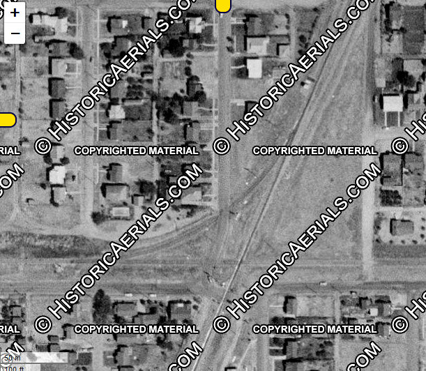
Below Left: ((c) historicaerials.com)
This 1956 image of the Bird's Siding crossing, it is evident that the location of the equipment cabinet at "West End,
Bird's" is too far north of the diamond to have been the site of the
cabin interlocker. Earlier imagery shows the cabin was in the southeast corner
of the diamond. A 1964 GC&SF timetable implies that Bird's Siding had
become an
automatic interlocker by then. If cattle pens ever existed east of the Santa Fe
tracks, 1946 imagery shows they'd been removed by then.
Below Right: About 1957,
Tower 53's interlocking plant was automated. This 1963 aerial
image ((c) historicaerials.com) shows that the tower remained standing, casting
a shadow to the north, perhaps in use for some other purpose. Later
imagery shows the tower was gone by 1968; its fate has not been determined.


Above Left: Facing northwest at the Tower 53 crossing, the former SP line comes
in from the southeast and joins the main track into Ney Yard.
(Jim King, c.2005)
Above Right: The switch at Tower 53 is now known as Midlothian Jct.
In this view, Tower
53 would have been visible across the Katy tracks. (Jim King, c.2005)
Below Left: Looking southeast
from the W. Morningside Dr. grade crossing,
the former SP tracks now curve to the south instead of crossing the Katy main
line. (Google Street View) Below Right:
Looking northwest, the former grade of the I&GN spur now carries Cole St. along
side Echo Lake, the former I&GN reservoir. (Google Street View)


Left and Above: The 1951 update to the 1910 Sanborn Insurance Co. map of Fort Worth
shows a two-story signal tower at the Polk's Tower crossing. The tower
was added by the update because it did not exist until 1926. |
Below:
This trackside concrete equipment cabinet is labeled "West End, Polk's".
Since the lines no longer crossed, there may
not have been any continuing purpose for the cabin and the control box
when this photo was taken in 2002.
(Jim King photo)
 |
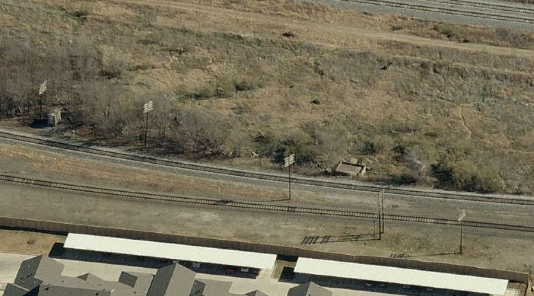
Below Left: Facing
east, this c.2002 bird's eye view of the
vicinity of Polk's Tower shows the equipment cabin sitting at the edge of the brush
on the far left side of the image, adjacent to the utility pole that is
also visible in the above photo. Of greater interest
is the potential remnant of the tower's foundation sitting trackside. Note that the path of the utility
poles traces the original route of the Santa Fe right-of-way, undeterred by the
swapping of main lines. (Microsoft Visual Earth)
Below Right: This satellite
image from 2023 shows that the Santa Fe line is now double track. The concrete
foundation, possibly of Tower 126, remains visible beside the UP track near the
bottom of the image, and the interlocker cabin (presumably abandoned) sits
trackside at the top edge of the image. Katy tracks are barely visible in the
lower right corner.