Texas Railroad History - Amarillo Area Towers
Tower 75, Tower 153, Tower 177 and Tower 209
Crossings of the Santa Fe, the
Rock Island, and the Fort Worth & Denver railroads
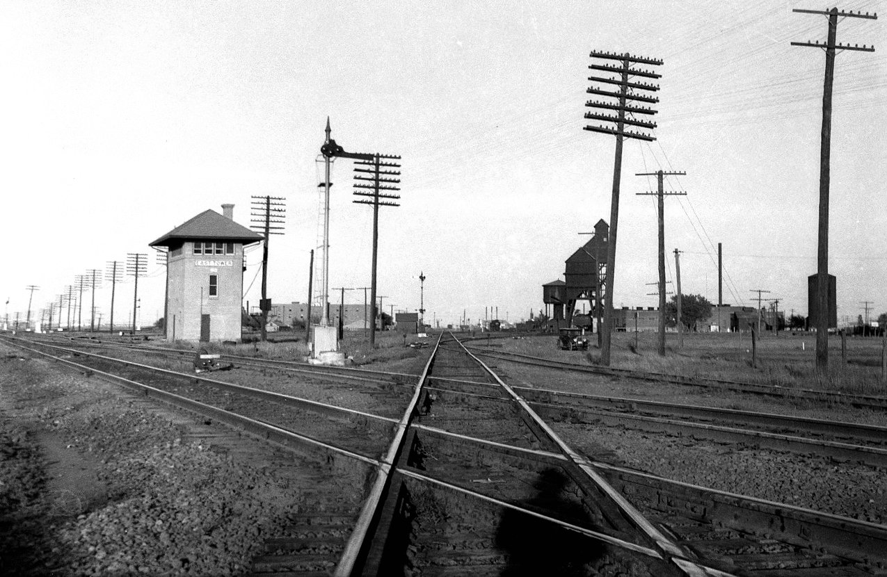
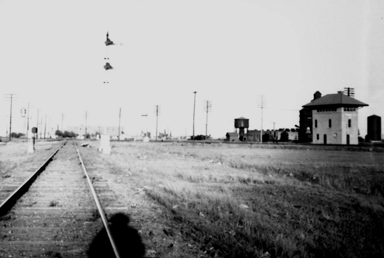
Above: Looking east along the
Fort Worth and Denver City (FW&DC) tracks, John W Barriger III captured this photo of
Tower 75 on the afternoon of May 5, 1940. Judging by the human shadow in the
foreground, Barriger was standing between the rails and not near his
business car since the setting west sun had a clear view of his back. The sign
on the tower says "East Tower", the moniker by which it was known to Amarillo
railroaders. Below: This photo by Barriger
faces east-northeast along the Panhandle & Santa Fe (P&SF) tracks. Note that
searchlight signals have replaced the semaphore signal visible in the above
photo, which was taken nearly two decades earlier. (both photos, John W
Barriger III National Railroad Library)
Amarillo was founded in 1887 by savvy businessmen
looking to capitalize on a new rail line being built across the Texas Panhandle
by the Fort Worth & Denver City (FW&DC) Railway ("City" was dropped in 1951,
thereafter simply FW&D.) About the same time, the Southern Kansas Railway, a
subsidiary of the Atchison, Topeka and Santa Fe Railway, was building a line
from Kansas through northern Oklahoma into the Texas Panhandle. These tracks
terminated 24 miles northeast of Amarillo at a newly founded town called
Panhandle City. In late 1887, Ft. Worth interests chartered the Panhandle
Railway to build a 15-mile connection between the Southern Kansas at Panhandle
City and the FW&DC at Washburn, 14 miles east-southeast of Amarillo. The idea
was to supply a route for cattle ranches near Panhandle City to ship livestock
to Fort Worth's stockyards via the connection at Washburn. Meanwhile, Amarillo was
well served by rail connections to
both Ft. Worth and Denver, and it was surrounded by large ranches filled with
bountiful prairie grasses. By the late 1890s, Amarillo had become the
principal city of the Panhandle and a major center for shipping cattle.
In April, 1898, the Southern Kansas leased the Panhandle Railway and negotiated
trackage rights on the FW&DC between Washburn and Amarillo. A few months
later in December, the Panhandle Railway was sold by its receivers to a
Southern Kansas employee (its Treasurer) who was acting on behalf of the
railroad to make the purchase. The existing lease was continued until
January 1, 1900, at which point the Panhandle Railway was deeded to the
Southern Kansas. The two-step acquisition process was odd, but
the rationale for leasing (and ultimately owning) the line was
understood by everyone. Eight months earlier, a story in the
El Paso Daily Herald of August 18, 1897 had
specifically identified Washburn as the endpoint for a new railroad to be built
out of Roswell, New Mexico by railroad developer James J. Hagerman. Santa Fe
expected to use the Washburn connection as a gateway to vast agricultural areas
well south of Amarillo and into eastern New Mexico.
James John Hagerman was an industrialist known best for
developing mines and railroads in Colorado, New Mexico and Texas. [He does not
appear to have been directly related to James Hagerman, the General Solicitor for the Missouri, Kansas & Texas Railroad
who was active in Texas railroading at the same time.] In 1890, Hagerman had built the
Pecos River Railroad from Pecos, Texas to Roswell, New Mexico, and by 1896, he
had begun planning a lengthy extension from Roswell to the Texas Panhandle. His
goal was to facilitate shipping cattle from ranches in southeastern New Mexico
to stockyards in Kansas City. Hagerman would need a Santa Fe connection to reach
Kansas City, so he aimed for Washburn where the Panhandle Railway tracks led to
the Santa Fe at Panhandle City. The Panhandle Railway was still in receivership,
but it was
reasonable for Hagerman to assume that a trackage rights agreement to reach
Panhandle City would be
attainable, and he may already have known of Santa Fe's plans to acquire the
Panhandle Railway.
In 1898, Hagerman chartered the Pecos and Northern Texas (P&NT) Railway
for the Texas portion of his planned Roswell - Washburn line. Instead of
Washburn, he began at Amarillo -- its civic leaders had prevailed upon Santa Fe
to move the connection out of Washburn. Hagerman built south to
Canyon and then southwest to the state line at
Texico, New Mexico (where the town of Farwell was
established several years later on the Texas side of the border.) At Texico, the P&NT connected to the Pecos Valley & Northeastern Railway
(also founded by Hagerman) which followed the same southwest heading to
Portales and Roswell. [The line no longer goes southwest at the state line; it
runs west from Farwell ten miles to Clovis and then due south 6.5 miles to
intersect the original tracks several miles northeast of Portales, but Clovis
did not exist in 1899.] At Roswell, an existing railroad (also founded by
Hagerman) continued south through Eddy, New Mexico (now Carlsbad) and veered
southeast to connect to the Pecos River Railroad
at the Texas border, terminating at Pecos, Texas. [And if you speculate that there must be a Hagerman,
NM somewhere along this route...you'd be right!]
The Roswell - Amarillo line opened in February, 1899, and in 1901, Hagerman sold
the P&NT and his New Mexico railroads to Santa Fe, a move that surprised no one.
In 1908, Santa Fe opened the Belen Cutoff
across eastern New Mexico, creating an alternate route for a portion of its
transcontinental main line between Kansas City and Los Angeles. The eastern
terminus of the Belen Cutoff was its existing Roswell - Amarillo line at Texico,
across the border from Farwell. The new town of Clovis was built nearby to host
a major yard and maintenance facility. As Santa Fe was preparing for substantial
long distance traffic moving through Amarillo, continuing to use the route from
Amarillo to Panhandle City via Washburn no longer made sense (not that it ever
did after the P&NT line opened.) Instead, Santa Fe extended the Southern Kansas
tracks from Panhandle City directly into Amarillo, a distance of 25 miles. The
tracks between Panhandle City and Washburn were immediately abandoned by Santa
Fe, causing Tower 48 at Yarnall to close.
In
1914, the Texas operating component of the Southern Kansas Railway was renamed
Panhandle & Santa Fe (P&SF), and this became the railroad under which Santa Fe's
operations in west Texas would be consolidated. By this time, Santa Fe had
already used the P&NT charter to build from Canyon
south to Plainview, farther south to
Lubbock in
1910, and another 200 miles southeast through
Sweetwater to Coleman in 1911. Additional
branch lines had been (or soon would be) built, ultimately increasing the P&NT's
rail network to 570 miles. Most of the P&NT was leased to the P&SF; it
ceased to operate trains but continued to exist on paper, and was formally merged into the P&SF in 1948.
In 1904, the last major
railroad to enter Amarillo was the Chicago, Rock Island
and Gulf (CRI&G) as it built through the area on a due west heading. Rock
Island's purpose for this line was to extend their Memphis - Oklahoma City Choctaw Route west to Tucumcari,
New Mexico where it would connect with a line that SP operated between Tucumcari
and El Paso. At El Paso, SP's southern
transcontinental route proceeded across New Mexico and Arizona to southern
California. The
Choctaw Route extension created a route from Little Rock to El Paso via
Tucumcari that competed with Missouri Pacific and T&P's combined route from
Little Rock to El Paso via Texarkana.
In 1927, Rock Island
began building a line north from Amarillo to
Liberal, Kansas. Liberal was also on Rock Island's
Golden State Route, a route from Chicago to Tucumcari and onward to Los
Angeles via the SP connection through El Paso. When completed in 1929, the
Amarillo - Liberal line combined with the westerly extension of the Choctaw
Route to create an alternate route between Liberal and
Tucumcari. The primary purpose, however, was to
access oil and gas development northeast of Amarillo and agricultural commerce
in the vast underserved farming areas farther north.
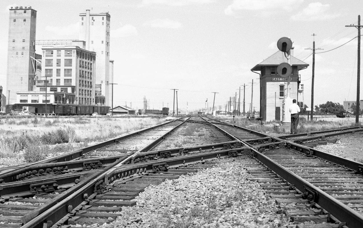
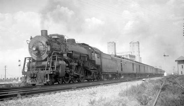
Above: On May 5, 1940, Barriger took this
photo facing east on the Rock Island tracks from west of the Santa Fe diamond
(which is visible directly ahead.) The FW&DC tracks are behind East Tower
generally parallel to the Rock Island tracks, passing beside the circular water tower
as seen in the first Barriger photo. The Santa Fe tracks cross both rail
lines at an acute angle. Again, the shadow suggests it was late
afternoon. (John W Barriger III National Railroad Library)
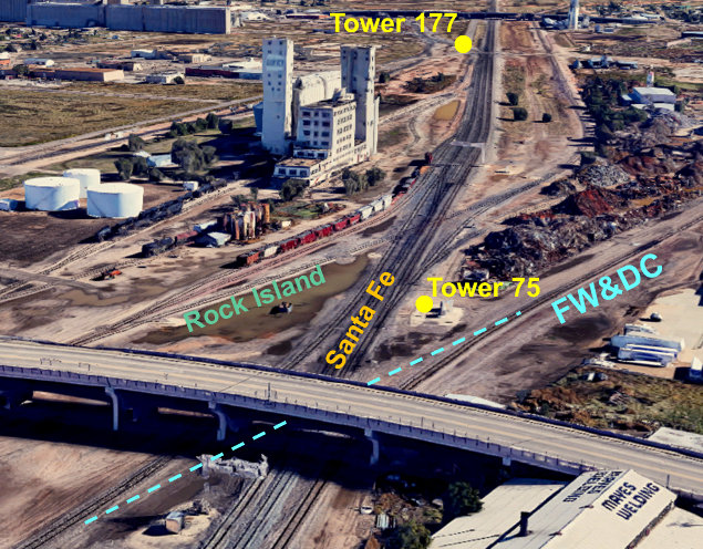
The 1908 extension of the Southern Kansas line from
Panhandle City to Amarillo provided the impetus to
establish the first interlocker in Amarillo. Tower 75 was authorized for operation by the Railroad Commission
of Texas (RCT) on July 6, 1908, appearing in the list published in the
1909 RCT Annual Report as a
27-function mechanical plant serving a crossing of the FW&DC, the CRI&G and the
Southern Kansas (which changed to "P&SF" in the 1915 report.) Details of the
original tower structure and its location have not been determined. The concrete
tower photographed by Barriger and many others was built in 1927.
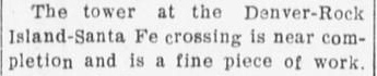 Left:
Though it was commissioned by RCT on July 6, ten days later, the July 16, 1908
edition of the Amarillo Weekly Herald
described the tower as "near completion".
Left:
Though it was commissioned by RCT on July 6, ten days later, the July 16, 1908
edition of the Amarillo Weekly Herald
described the tower as "near completion".
In 1929, RCT authorized a new interlocker, Tower 153, in the P&SF
yards. Although no other railroad was involved with Tower 153, it was authorized
pursuant to RCT policy that had evolved in the 1920s requiring that all
interlockers be authorized, even those involving only one railroad. The P&SF yard interlocker
established in Canyon in 1927 had already set this
precedent for Santa Fe. RCT files at DeGolyer Library state that Tower 153
was a 12-function electric interlocker with controls located at the "Junior Yard
Office", and that there was "no connection
with a foreign line".
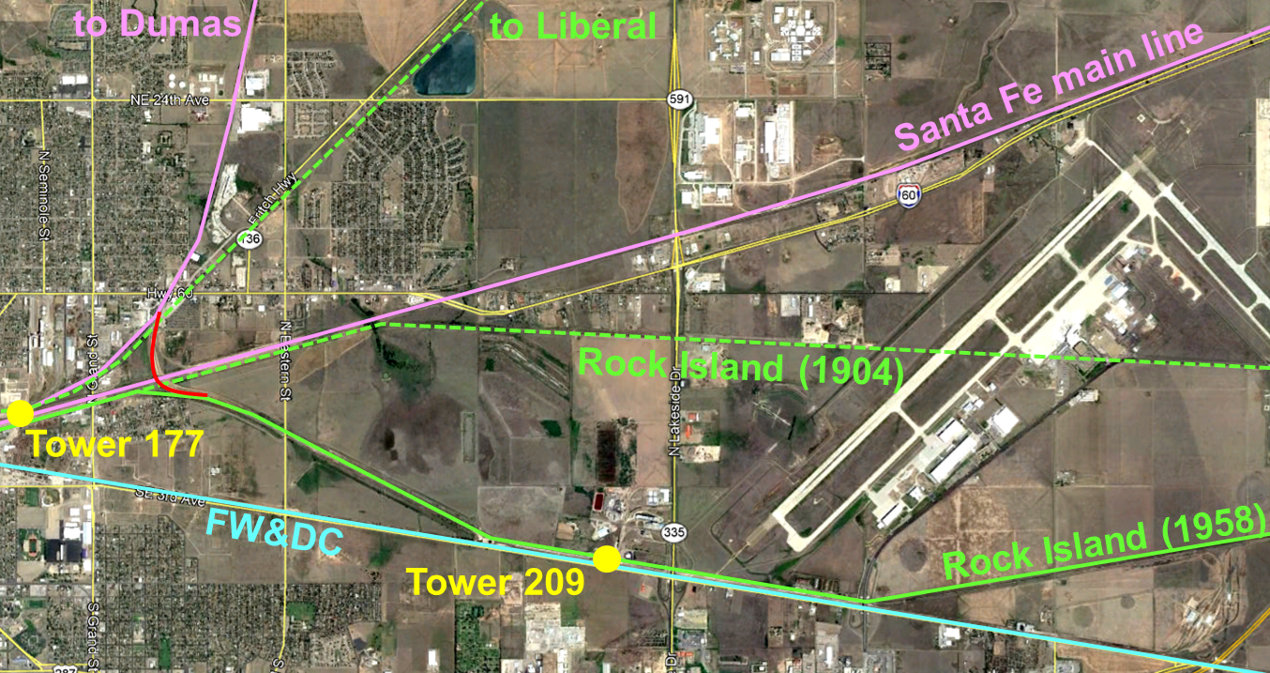
In 1931, Santa Fe built a new line north from
Amarillo to Boise City, Oklahoma and beyond, passing through the Texas towns of Dumas,
Etter and
Stratford. In Amarillo, this line split off the
P&SF main line at "Dumas Junction" very close to where it crossed Rock Island's
line to Liberal. To control this crossing, Tower 177 was commissioned by RCT as
a 12-function electrical interlocker on July 8, 1931.
In 1955, a major expansion began
at Amarillo Air Force Base (now Rick Husband Amarillo International Airport) when it was
chosen to host B-52 bombers for Strategic Air Command. The base sat beside
Amarillo's municipal airport and shared its runways. The Choctaw Route
tracks were a quarter mile south of the airport; a new runway would cross
directly through Rock Island's right-of-way. To relocate their line, Rock Island built
new tracks east of the base that angled the
Choctaw Route to the southwest all the way down to the FW&D
right-of-way. It then paralleled the FW&D for two miles west before angling back
to the northwest to rejoin the existing Choctaw Route tracks approximately 1.2
miles north-northeast of Tower 75. Along the shared FW&D right-of-way, the newly
relocated Choctaw Route crossed an existing FW&D spur that ran a short
distance north. To protect this crossing, an "Electric Locked
Crossing Gate" was placed in service at the spur track diamond on September 10,
1958. The next day, Rock Island wrote a letter to RCT
requesting a numbered interlocker assignment. This request was later granted as Tower 209.
This gate interlocker caused distant signals on the Rock Island to illuminate
red whenever the gate was unlocked.
Today, all of the surviving tracks
associated with Towers 75, 153, 177 and 209 have been absorbed into Burlington
Northern Santa Fe (BNSF).
Rail Map of Downtown Amarillo c.1955 (courtesy
of Jeff Ford, with annotations by Jim King)
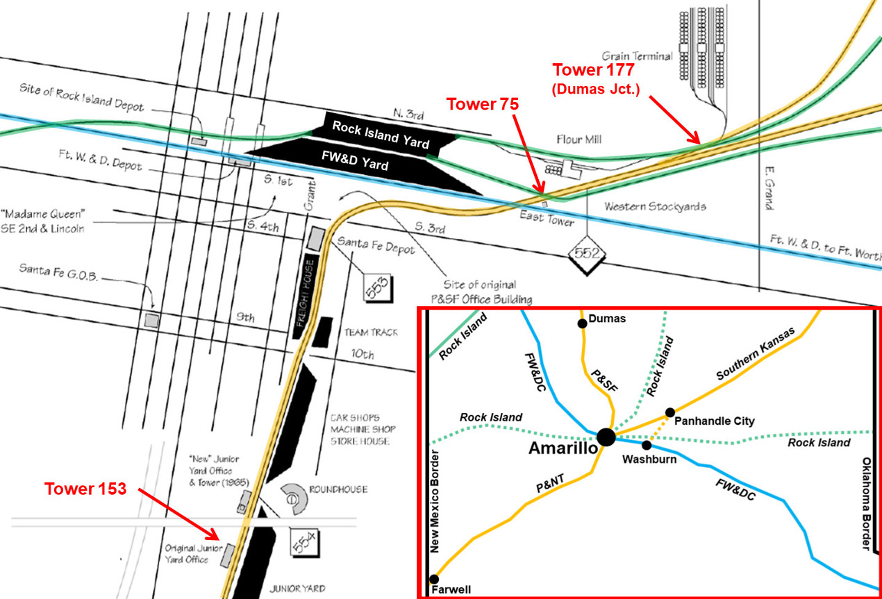
Above: This map details the
track layout near downtown Amarillo in approximately 1955, with some additional
details through 1965. The color annotations show the railroads and the
interlocker locations. Tower 75 (East Tower) was the primary
interlocker for Amarillo handling a junction of three main lines. When the "New
Junior Yard Office and Tower" was built in 1965 (presumably necessitated by the
elevated I-40 freeway bisecting the yard), the Tower 153 interlocker was
likely retired (if it was even still in operation.) Tower 177
(Dumas Junction) was located where the P&SF line to Dumas crossed the Rock
Island line to Liberal. The inset in the lower right corner of the image shows the general heritage of
Amarillo's rail lines. Tower 48 was located at
Yarnall where the ex-Panhandle Railway line (acquired by Santa Fe) between Washburn and Panhandle City
crossed the Rock Island. The solid lines all remain in service as of 2019; all
of them are owned by BNSF
except for the Rock Island line in the upper left corner of the inset which is now owned by
Union Pacific. It was part of Rock Island's Golden State Route
through Dalhart and
Stratford, Texas.
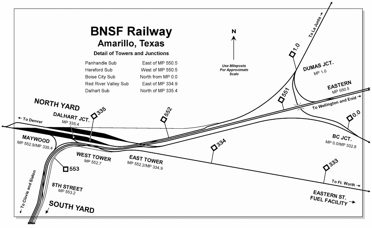
Below:
Jeff Ford supplies this updated map from c.2006 with this explanation:
"East Tower became part of a larger interlocking
'complex' in 1998 with the installation of what is referred to as
West Tower. In 2005-06, the complex grew again
to the west with the inclusion of a control point known as 8th St. In 2018, BNSF
completed a fourth main track project which included work in the vicinity of
East Tower where the Red River Valley sub Main 1 was reconfigured to run
continuously into Hereford Sub Main 3, east-to-west."
Evan Werkema describes Tower
75...
"The 15x30 tower was built in 1927 to a plan similar to the
concrete interlocking tower standard plans shown on pages 218-221 of Santa Fe
System Standards, Volume 2. The stairway, door, and window placement and other
details deviated from the plan. ... The tower's duties diminished with the demise of the Rock
Island. It was closed in April 1986 and demolished in mid-1990."
Above: Since Tower 75 was authorized in 1908, the
1927 concrete tower must have replaced an
earlier structure.
On April 8, 1953, the United States Court of Appeals for the Fifth Circuit
issued a
ruling in a case involving the Panhandle & Santa Fe (P&SF) Railway at
Amarillo. The P&SF was the defendant accused of operating several train
movements in violation of the Safety Appliance Act. The ruling includes this
interesting description of the tracks and operations associated with East Tower.
"As shown by a map of the yards, the
defendant's classification yard, referred to as the West Yard, is located to the
left, or west, of the major portion of the Amarillo Yards and the tracks of Fort
Worth [and Denver] and those of Rock Island. The points where these lines
converge and cross is protected by an interlocking plant, controlled from what
is denominated East Tower. Beyond the interlocking plant, and some five miles
from the classification yards of defendant on its Dumas Branch, is located the
Amarillo Stock Yards. It is served by an industry track. Southwesterly of East
Tower, and the point of convergence and crossing of the lines of the three
carriers, is located the Western Stock Yard Corporation, some two miles from West Yard, or classification tracks, of the defendant. East of the point of
convergence and crossing of the three main lines are the interchange tracks of
the defendant and the Rock Island. These tracks are some two miles from the
defendant's West Yard. Each of the movements here in question moved within the
interlocking plant. The briefs tell us that an interlocking plant is a system or
arrangement of levers, switches, lights and derails so interconnected that they
must be arranged in a predetermined order for the selected movements of the
plant. In the case of this plant, the movements are controlled by an operator in
the East Tower who determines the priority of movement as between trains on the
different railroads that attempt to use at the same time the area defined by the
limits of the interlocking, and by manipulating levers indicates that fact by a
system of lights. Rails which do not have priority are broken at points about
400 feet in advance of the crossings by means of what is called a "split-rail"
derail."
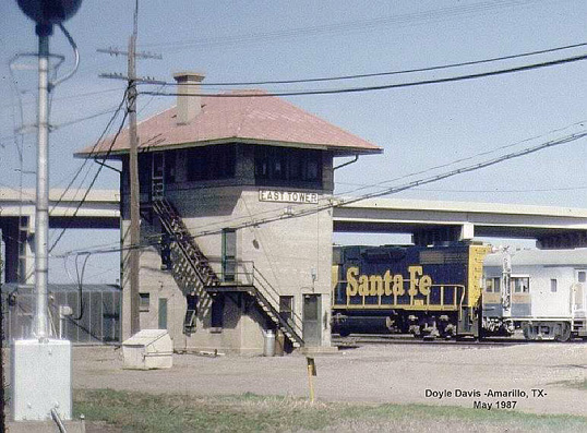
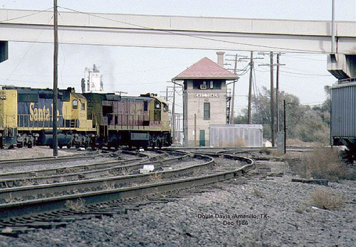
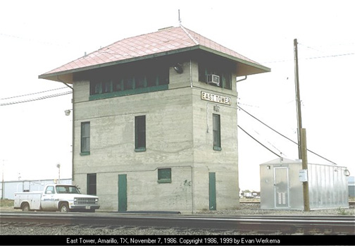
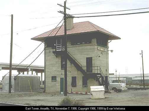
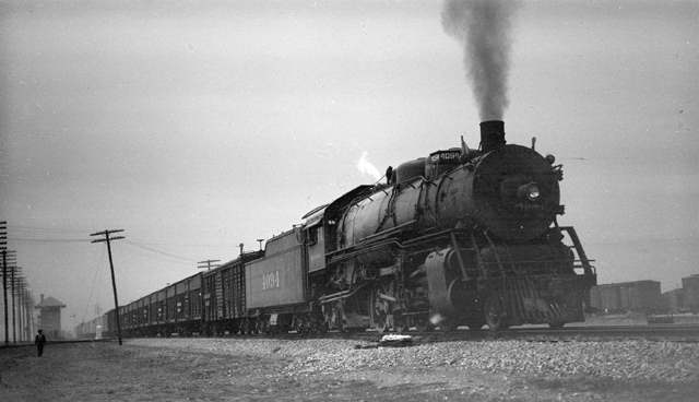
Above Left and Right: Tower
75 photos by Doyle Davis. Below Left: Santa Fe Train #9,
The Navajo,
passes Tower 75 on July 22, 1936. Below Right: an eastbound Santa Fe freight
passes Tower 75 on April 4, 1936
(Otto Perry photographs, courtesy
Denver Public
Library)
 |
Left: These
two copyrighted images are from historicaerials.com showing the
re-location of the Choctaw Route caused by the expansion of
Amarillo Air Force Base. The upper image from 1953 shows the Amarillo
municipal airport with the Santa Fe main line along the north side of
the air field. The Choctaw Route ran parallel to (and a quarter
mile south of) the south boundary of the airport. The Amarillo Army Air
Field immediately east of the airport was a training center that shared
the airport's runways. Closed after the war, the base was reactivated in
1951 as Amarillo Air Force Base and given a mission of training jet
mechanics. In 1955, the decision to host operational B-52s at the base
meant that a much longer runway would be needed. This required Rock
Island to relocate its Choctaw Route tracks farther south. The
new runway extended almost all the way south to the FW&D right-of-way.
The lower image, from 1967, shows the abandoned Choctaw Route
right-of-way through the base (green dashed line), replaced by new
tracks that included a two mile section parallel to the FW&D. West of
the runway, the Choctaw Route
angled slightly more northwest and re-joined the
original tracks where they paralleled the Santa Fe main line (before
crossing over at Tower 75.) The precise date of Rock Island's relocation
project has not been determined, but their efforts to establish Tower
209, where the new track crossed a FW&D spur, occurred in September,
1958. Since Rock Island took responsibility for resolving the
interlocking issue for this crossing, it is reasonable to assume that
they were the "second railroad" that created the crossing. Hence, this
spur most likely already existed and the
crossing materialized when the relocation project built across the spur,
probably in the summer of 1958. |
Above: This consolidated view of the Choctaw Route
project shows the location of Tower 209 where the new track crossed a FW&D spur.
The re-located Rock Island tracks are still in use by BNSF. They terminate to
the east just beyond the large Progress Rail Services freight car
repair facility that sits between the Rock Island and FW&D tracks (served by
both) visible in the lower right corner of the image. Where the Choctaw
Route rejoined the Santa Fe main line right-of-way near Tower 177, BNSF
built a new grade-separated connector (shown in
red
) to allow traffic between the Santa Fe line to Dumas (BNSF
Boise City Subdivision) and the FW&D
line to Fort Worth (BNSF Red River Valley Subdivision) to bypass the Amarillo yards.
Google Maps, Simulated 3-D Views
(with rail line heritage annotations)
Above Left:
This 2019 view looks northeast along the Santa Fe main with
the Tower 75 site in the foreground and the Tower 177 crossing 0.7 miles distant. As the blue dashed line shows, the FW&D tracks no longer cross the
Santa Fe main at Tower 75. Instead, they curve and join the Santa Fe main track going
southwest (from westbound on the FW&D) or northeast (from eastbound on the
FW&D). The former Rock Island track across the Santa Fe main at Tower 75 was put back in
service c.2017. It curves due east past the tower site and parallels the main line to the point
where the re-located Choctaw Route
joined the Santa Fe right-of-way.
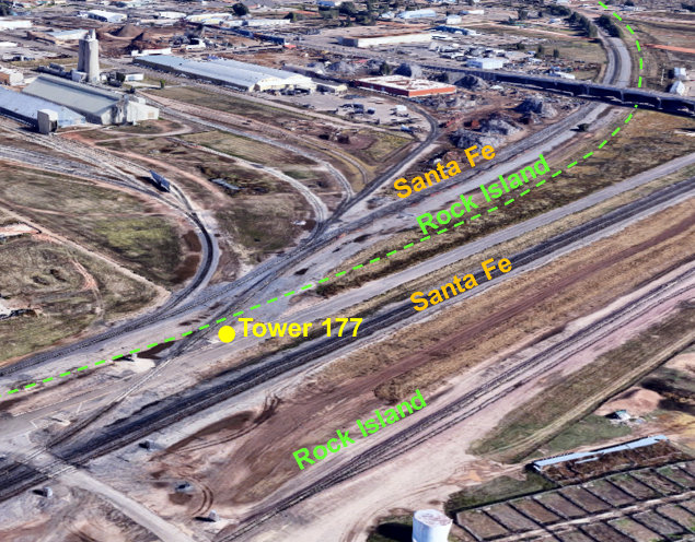
Above Right: Facing northeast,
the Santa Fe line to Dumas split off from the main line, crossed over the Rock
Island line to Liberal, and then paralleled it for about a mile. At that point
they diverged, with the line to Dumas swinging north while the Rock Island line
straightened to a northeast heading. Below
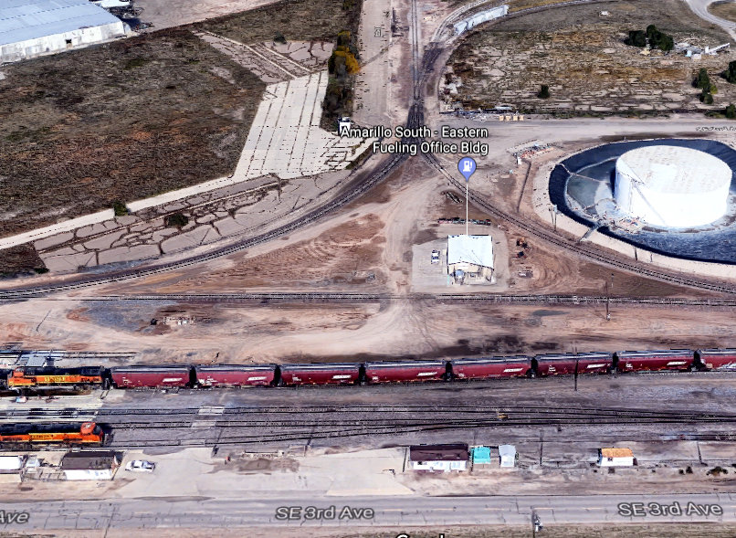
Left: This north-facing image shows the wye-track industry spur
that gave rise to the need for Tower 209 when the Choctaw Route
was relocated beside the FW&D main line. The rail cars are essentially sitting on the Rock Island right-of-way while the other BNSF locomotive is on a siding of
the FW&D main line. RCT files at DeGolyer Library
show that the southwest leg of the wye actually connected to the FW&D main
whereas the southeast leg only connected to the parallel track that is visible
along the south side of the Amarillo South-Eastern Fueling Office Bldg.
Tower 209's "Electric Locked Crossing Gate" was off the left edge of this image
just north of the diamond where the southwest leg crossed the Rock Island.
Neither the spur nor the industry area served by it appear on 1953 aerial imagery
of Amarillo, but it certainly existed by September, 1958
when Rock Island requested an interlocker assignment from RCT.
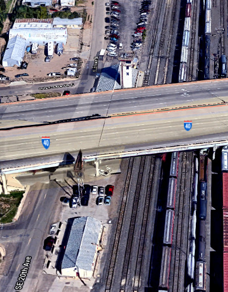
Below Right: The "Junior
Yard Office" that housed the Tower 153 interlocker still sits beside SE 20th
Ave. just south of the I-40 overpass (but is hopefully a newer structure than
existed when the interlocker was authorized in 1929!) The new yard office and
tower were built in 1965 and are visible immediately north of I-40. By
the mid-1960s, RCT had ceased issuing new numbers for interlockers; automation
had rendered their engineering design approvals
largely irrelevant. The new
tower was never numbered by RCT, and the precise fate
of the Tower 153 interlocker is unknown.